
The Mighty Five - Utah’s National Parks
Use the extensive research and sample itinerary below to plan a memorable 7-10 day trip to Zion, Bryce, Capitol Reef, Canyonlands, and Arches National Park. Each park has breathtaking and unique scenery - from Angel’s Landing, Thor’s Hammer, petroglyphs, vast landscapes, and stunning arches. You won’t want to skip any of these beautiful parks.
ZION NATIONAL PARK
THE SHUTTLE SYSTEM:
The shuttles run February through November, and are free to ride.
Check the Zion National Park Shuttle Schedule
Go early to find parking - it gets packed FAST. The best option is to leave your car at the Visitors Center, but if the lot is full you might have to pay to park in Springdale and get a shuttle to the park entrance.
The Zion Canyon Shuttle will take you to the most scenic parts of the park. Ride this line to get to hikes like Angels Landing, Emerald Falls, The Narrows etc. The shuttle line begins at the Zion Visitors Center.
If you want to see Zion before or after the shuttles are running you will need a bicycle. Biking is allowed on all roadways and the Pa’rus Trail. You can read more about bicycling in Zion National Park on the NPS sites.
HIKING NOTES
Zion Sections (Check out the National Park Website to see detailed info on the hikes in every area, mileage, times, shuttle stops, water filling stations etc.)
Best hiking in Zion: Angels Landing, Observation Point, The Narrows, The Subway, Lower, Middle and Upper Emerald Pools, and the West Rim Trail.
Main Canyon/Zion Canyon Section. Angels Landing, Weeping Rock, Emerald Pools, the Lodge, the Visitors Center. This is the most popular section of the park, and where you’ll end up from the Springdale Park entrance.
Angels Landing - this hike is the most popular hike in the park. It will take about 4 hours to complete the 4.8 mile round trip hike with 1,630 ft elevation gain. The hike starts at Shuttle Stop 6, the Grotto Trailhead, and goes along the lower West Rim Trail. Everyone who wants to hike from Scouts Lookout to Angels Landing along the half-mile section of trail with chains needs to have a permit. Get a permit by applying to a Seasonal Lottery or by applying for the Day-before Lottery.
Pa’rus Trail - a 3.5 mile round trip paved trail that follows the Virgin River from the South Campground to Canyon Junction. Start from Shuttle stop 1 or 3. Canyon Junction Bridge is a great spot to watch the sunset. Get there early to get a parking spot on the side of the road near the bridge.
Grotto Trail - 1 mile round trip trail connects the Zion Lodge to the Grotto and is near the road most of the way. Restrooms are available at both the Lodge and the Grotto. When the shuttle is not in operation and the parking is full at the Grotto, this trail is a lovely alternate way to reach the Grotto. Start from shuttle stop 5 or 6.
Weeping Rock Trail - Start from Shuttle Stop #7. 0.4 mile round trip hike. Short and steep. Trail ends at a rock alcove with dripping springs.
Riverside Walk - Start from Shuttle Stop #7. 2.2 mile round trip hike (1.5 hours). This paved trail follows the Virgin River along the bottom of a narrow canyon. Trailside exhibits. The first 0.4 miles of the trail is accessible but past that point there are several steep slopes. This trail accesses the bottom-up Narrows route. Restrooms and water filling stations are available at the Temple of Sinawava.
Watchman Trail - the iconic rock formation you always see pictures of in Zion National Park. It is a beautiful sunset hike. Start from Shuttle Stop #1 (Visitors Center). The trailhead is up the canyon and across the road. Stay along the river to begin the trail. 3.3 miles round trip (2 hours). The trail ends at a viewpoint of the Temples and Towers, lower Zion Canyon, Watchman Peak, and Springdale.
Emerald Pools - 2 mile round trip hike to the upper pool. This is an easy entry trail into the park. Main attraction is the Lower Pool, but the upper pool is an amazing sandstone amphitheater. Morning and afternoon will be sunny. Shady in the evening. Start the hike at the Lodge or the Grotto. If leaving from the Lodge the trail to the lower pool is shorter (0.6 miles one way). Add another 0.6 miles one way to get the Upper Emerald Pool.
Lower Emerald Pool Trail. Start from Shuttle Stop #6. Trailhead across the road from the Grotto via the Kayenta Trail. 2.2 miles, 1.5 hour round trip. Leads to the pools below Middle Emerald Pools and the Upper Emerald Pools Trails. Minor drop-offs. The half-mile, one-way paved trail to the Lower Pools takes a little maneuvering but is easily manageable by all
Middle Emerald Pools Trail. Start from Shuttle Stop #6 (Kayenta Trail). Shuttle Stop to Start from: #6 Kayenta Trail. 2.2 miles, 1.5 hours round trip. An unpaved climb to a sandstone ledge that parallels the lower trail, but at a higher level. Moderate drop-offs. Keep going behind the back of the waterfall at the Lower Pool, up a narrow ledge on the face of the cliff to view hanging gardens and tree frogs. Continue until you reach the Middle Pools. Look down on the top of the waterfall that feeds into the Lower Pools. Some of this can be a little difficult, as it requires crossing streams and slippery areas. But the view is worth the trouble. Connects to the other Emerald Pools trails.
Upper Emerald Pool Trail. Start from Shuttle Stop #6. 3 miles, 2 hours round trip. A sandy and rocky trail that climbs to the Upper Emerald Pool at the base of a cliff. If you want to continue a little further past the Middle Pool with another 200 feet of elevation gain, you’ll find the source of the Emerald Pool waters. An 800-foot waterfall fills the large pool at the base of the cliff. This is the Upper Emerald Pool. You can also reach the Emerald Pools through the Kayenta Trail that begins from the Grotto Picnic Area and rises a quick 150-feet in elevation. You can loop back down via the Emerald Pools trail.
Kayenta Trail. Start from Shuttle Stop #6. 2 miles, 1.5 hours. An unpaved climb to the Emerald Pools. Connects the Grotto to the Emerald Pools Trails.
Canyon Overlook Trail. Requires personal transportation, no shuttle. Gorgeous “glowing” views of Zion Canyon at sunset. Trailhead located near the east entrance of the Zion-Mount Carmel Tunnel. An easy 1 mile hike, 1 hour round trip. Long drop-offs, mostly fenced. Rocky and uneven trail ends at a viewpoint for Pine Creek Canyon and lower Zion Canyon. Parking is extremely limited, be prepared to try multiple times. There are pit toilets in a parking lot about a quarter mile east of the trailhead.
Observation Point Trail - 8 miles round trip. The hike is very steep (ascends 2,000 feet) to the top of Mount Baldy with short sections of level strolls through beautiful Echo Canyon. A beautiful vista of Zion Canyon at the end. The shorter trail is closed due to a rockfall in 2019. **Observation Point gets mentioned a lot.
Desert Lowlands Section. Driest part of the park, so it’s good to visit in the offseason. Hike the Chinle Trail and Eagle Crags Trail. Southwest section of the park.
Kolob Canyon Section. Secluded area that is most famous for its red/pink colors. The hikes here are lesser known and all of them are out-and-back hikes. Trails include Timber Creek Overlook Trail, Taylor Creek Trail, La Verkin Creek Trail. Northwest section of the park.
Zion Narrows Section. One of the most popular hikes in the world as it takes hikers through a series of canyons carved by the Virgin River. Starting from the Temple of Sinawava, the Bottom-Up section of The Narrows is free to explore with no permit. A hike through The Narrows requires hiking in the Virgin River. You must get your feet wet since there is no trail. Most people choose to start their hike from the Temple of Sinawava via the Riverside Walk and then walk upstream (walk an hour to Mystery Falls, or as far as Big Spring, a strenuous 10 mile round trip hike) before turning around and hiking back down to the Temple of Sinawava. This will allow you to see some of the most spectacular and narrowest parts of the canyon.
Kolob Terrace Section. This is the central part of the park and is at higher elevation. Typically you are unable to access this area in the winter. There are some great campsites here. Another world-renowned hike - The Subway (strenuous 9+ mile hike, needs a permit). See the Archangel Falls.
Upper East Canyon Section. A very scenic drive. If you are driving from Zion to Bryce you will go this way. The Zion-Mt Carmel Tunnel is the main attraction and is sort of like the gateway into the park. Lots of rock formations, photo ops and pull-offs to explore.
LODGING
Watchman Campground - reserve 6 months in advance. No showers, but there are bathrooms with flush toilets. The shuttle stops here. Right next to the Visitor's Center. ***We stayed here and loved it!
Check Kolob Terrace Rd and BLM Land along 59 for free or “dispersed” camping options.
Springhill Suites by Marriot in Springdale
Zion National Park Lodge (varies from $199-$264/night)
VRBO options
The Historic Rose Cottage on VRBO ($235/night. Sleeps 4)
Under Canvas Zion - Glamping. It was rated one of the Top 20 Resorts in this area of the US,and sits about a 30 minute drive from the Zion National park entrance.
DINING
Cafe Soleil
Whiptail Grill
Spotted Dog
AREA ACTIVITIES
Scenic drive through Zion Canyon
Bike Pa’rus Trail + River Access trails
Horseback riding
$210 per person, multiple half day options to choose from.
This looks like it has some great options. $149-$169 for half day options.
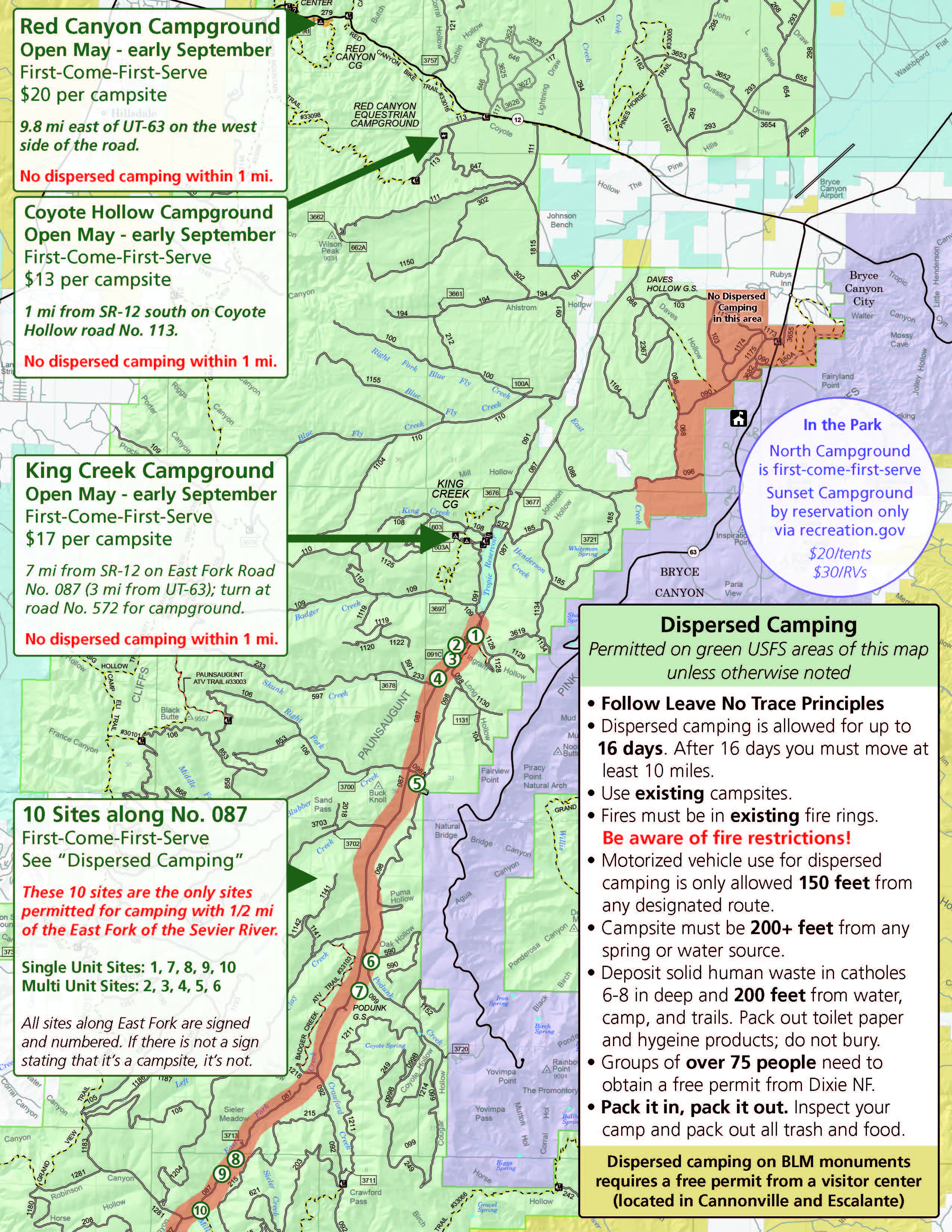
Bryce National Park
HIKING
Sunrise Point. Bright orange hues glowing as the sun comes up. No hiking necessary.
Navajo Loop Trail and Queens Garden Trail (most popular trails in the park) create a 3 mile loop which takes about 2 hours and has a 600 ft elevation change. Open views and unique hoodoos with iconic switchbacks and towering canyon walls. Start from Sunrise Point and descend Queen’s Garden Trail. End by ascending Navajo Loop to Sunset Point. Depending on the time of year, and which trails are open, your hike will end at Wall Street which has some great photo opportunities. At 11 am every day there is a park ranger at Sunset Point to give a Geology Talk.
The Fairyland Loop Trail - A quieter and more challenging 8 mile hike that gives a good workout thanks to the 1900 ft of elevation gain. The trail meanders around hoodoos, down into washes, up and over saddles and past ancient bristlecone pines that cling to the rocky cliff sides for dear life.
Peekaboo Loop Trail - This loop trail connects to Queens Garden and passes through the heart of the canyon. The trail gets its name from the fact that it bobs up and down in elevation many times, so hikers can “peek” out of the canyon. Most visitors don’t make it out to Peekaboo Loop and instead stick to exploring Sunrise Point or some of the shorter trails nearby. Those who make it are in for a fun hike, great perspectives of the famous hoodoos, sweeping canyon views and a good workout.
Mossy Cave and waterfall in the summer. This can also be accessed from outside of the park at a pull off.
Figure 8 Trail
Best Driving Vistas (The scenic drive is 36 miles roundtrip, takes about 3 hours)
Bryce Canyon Scenic Drive (Highway 63) has breathtaking vistas, and is one of the highest elevation roads in any National Park. Bryce Canyon is known for its massive orange hoodoo formations.
There are 15 scenic vantage points along the way.
Don’t miss Inspiration Point (where the massive Bryce Amphitheater is in full view. With an elevation of about 8,000 feet, it’s an exhilarating experience to look down into the canyon from the rim).
Rainbow Point, Bryce Point, Paria View, Fairview and Piracy Point are additional highlights.
LODGING
Bryce is at high elevation (around 8,000 ft). Spring snow storms are common - keep that in mind with your lodging plans!
Bryce Canyon Lodge (open April through October)
Camping
North Campground is first come first served October through May, and by reservation the rest of the year. $30/night.
Sunset Campground ($20/tents, $30/RV) or BLM land outside the park. No electricity or showers. They are open April 15th- October 31st.
Check out this website for info on cheap area camping.
Bryce Canyon Pines Campground has hot showers and a restaurant on site. $70 for a campervan RV site.
Red Canyon RV Park has showers - $40/night. They are open May 15th through October 15th.
Under Canvas Bryce Canyon - Glamping
VRBO option Canyon View Home is a 1 bedroom with a beautiful view.
Bryce Canyon City Hotels (5 minute drive from the park):
Ruby’s Inn RV Park and Campground (only open March 23rd-October)
Best Western Plus Ruby’s Inn - free breakfast, laundromat and indoor pool. ***This is where we stayed, and we were very satisfied with the room and food.
Best Western Plus Bryce Canyon Grand - free breakfast, indoor pool.
DINING
Ruby’s Inn - dinner buffet
Ebenezer’s Dinner Show (open April through October)
Grocery shop in Springdale before leaving Zion. Food options are sparse in Bryce. You can stop in Kanab, but it will add time to your trip.
AREA ACTIVITIES
Check out Old Bryce Town for souvenirs and shopping.
Red Canyon is a worthwhile side trip along Scenic Byway 12. Check out the .7-mile Arches Trail where you will walk by hoodoos, arches, and other interesting red rock formations.
Ruby’s Inn Rodeo runs May through August.
Soaring Utah VR Experience. $11 a ticket at Ruby’s Inn.
Snowshoeing (free when you sign up for a ranger led hike or rent from Ruby’s Campground) or Cross Country skiing.
Horseback riding trail rides through Ruby’s Horseback Adventures.
Canyon Trail Rides (official NPS concessionaire) for a 3 hour horseback ride on Peekaboo Loop (April through October).
Rent Bikes
Rent a bike for 8 hours or e-bikes for 4 hours at the Historic Service Station on Lodge Loop Rd or from Ruby’s Inn RV Park and Campground. Elevation gain runs from north to south to start at Inspiration Point for a smooth downhill ride. Shuttle buses can store 2 bikes on their front rack.
5 miles of a 2 lane path starting at the shuttle station north of the park and continuing to the visitor center, Sunrise Point, Sunset Point, and Inspiration Point.
Rent an ATV
Ruby’s ATV Tours, Bryce Canyon ATV Adventures, and Bryce Canyon Off-Road Rentals are in Bryce Canyon City. Grand Staircase ATV Tours are out of Tropic.
Capitol Reef National Park
HIKING
Petroglyph Panel - right at the entrance to Capitol Reef pull-off to take a short walk to view incredible rock drawings that date back to between 300 – 1300 A.D.
Cassidy Arch Trail (3.1 miles).
Hike to Hickman Natural Bridge - a 1.7 mile out and back hike.
Fremont River Hike - pick up the trail in the campground and enjoy a stunning 360 view at the end of the trail. ***This was our favorite hike at Capitol Reef.
Watch the sunset at Sunset Point. There is a short 0.3 mile hike to a scenic overlook. Access this trail from the Goosenecks Overlook parking lot.
Drives:
Cathedral Valley Road - you’ll need a high clearance vehicle, and an extra day for your trip. It’s a 4 hour loop. Make sure to get to the Temple of the Moon and Sun (pointed rocks shooting out of the ground).
Capitol Reef Scenic Byway - features large rock formations, canyon views and some dirt roads. It will take about 1.5 hours to complete the drive. The 8 mile road goes through the start of the Waterpocket Fold (the famous geological feature). At the end of the paved scenic drive you can take the last stretch of unpaved road to the Capitol Gorge Trail. This hike takes you along the historic pathway that settlers used to pass through the Waterpocket Fold in the late 1800s.
ADDITIONAL NOTES
Check the NPS website for road closures. Roads can flood in the spring. When we visited there was a lot of road construction and speed bumps to navigate.
Park Elevation - 5500 feet. As early as May temperatures are in the 90s.
This area is super cute. Lots of picnic areas and little farmhouses.
LODGING
SkyRidge Inn ($200-$350/night)
Camping
Fruita Campground is reservable starting March 1st. No electricity. But there are restrooms with flushable toilets. Reservations 6 months in advance. $25/night. ***We stayed here and loved our spot right by the river and apple orchard.
There are 2 free primitive campgrounds as well (sound like they may be difficult to get to).
Camping Alternatives are listed here. This gives info on BLM land near Beas Lewis Flat Road.
DINING
Capitol Burger (closed November through March)
Gifford House for pie (opens March 14th (Pi Day) for the season). There’s a picnic area across from the Gifford House.
Canyonlands National Park and Moab
HIKING
Canyonlands is known for its beautiful vistas, scenic overlooks and adventure, but the hikes aren’t as accessible. The Colorado and Green Rivers form a Y-shape that divides Canyonlands National Park into four separate districts. The three land-based districts are inaccessible to one another from within the park, meaning that long drives are required to see each of them :
Island in the Sky
Most visited because of its proximity to Moab. It has a Visitors Center, a paved scenic road, hikes, and the White Rim Road (takes several days to drive or bike).
Check out the 1.8 mile White Rim Overlook Trail.
Drive the Grand View Point Road with stops at all the lookouts (Shafer Canyon Overlook where you can watch Jeeps crawl down the switchbacks of Shafer Trail, Green River Overlook, Buck Canyon Overlook, and ending at Grand View Point to enjoy one of the Southwest's most sweeping views, where the road ends.
Walk the 2-mile round trip Grand View Point trail for panoramic views. ***We really enjoyed this hike.
Mesa Arch, an easy half-mile round-trip hike to a 27 ft-long rock arch on a cliff edge with a beautiful view of the La Sal Mountains. This is the most popular thing to see at Canyonlands, and can be VERY busy at sunrise with photographers.
Take the Upheaval Dome Road and park at the end (you’ll get to a turn around loop). Then take the 1.7 mile Upheaval Dome Trail to see the first and second overlooks of the site of a meteor impact. Moderate hike.
For sunset check out Grand View Point for sunset (no hiking for the view) or Green River overlook.
The Needles - backcountry. Need 4 wheel drive and hiking to explore
The Maze - very remote.
The Rivers - see this area from flatwater tours of the Colorado or Green River.
Check out the Moab Information Center for their events calendar and information on bike routes. The Mill Creek Parkway is a paved walkway going through the heart of Moab.
Museums
Moab Museum
Moab Museum of Film and Western Heritage
Moab Giants (intersection of Hwys 191 and 313) has a 3D cinema and a museum and hiking trail to take you to the prehistoric world of dinosaurs.
Scenic Byways to drive:
Potash-Lower Colorado River Scenic Byway (U-279). Takes an hour. At 5.1 miles several petroglyph panels are visible on cliffs on the right side of the highway. The Poison Spider Mesa Trail is a short hike offering additional petroglyphs.
Upper Colorado River Scenic Byway (U-128). Takes 2 hours. There are public camping options along this byway. There is a free museum about all of the TV shows and commercials filmed in the area.
Dead Horse Mesa Scenic Byway (US-313). Takes 2 hours minimum.
Horseshoe Canyon is nicknamed the "Louvre of the Southwest" for its huge panels of petroglyphs, and is one of the most impressive collections of rock art in North America. You have to drive for an hour on a dirt road to access this.
DINING
in Moab - Milt’s Stop and Eat Diner for burgers, Arches Thai, Sultan Mediterranean Grill have all been recommended.
If you’re looking for an evening outing, Canyonlands by Day and Night offers a cowboy-style, Dutch oven dinner followed by a guided, two-hour cruise down the Colorado River on the Moab Queen II. On the return trip, you listen to music and stories about the area’s cowboy and Native American history while floating by the illuminated canyon walls.
LODGING
Under Canvas Moab for glamping.
Luxury Condo - Beautiful 2BR condo near the heart of Moab.
Hotels
Lazy Lizard Hostel - $46/night for a private room with access to showers.
Big Horn Lodge - looks old but clean. $67.95/night
Best Western Plus Canyonlands - $73.92 with their no cancel policy. Free hot breakfast.
Red Stone Inn - hot tub, $169.95/night
Camping- check out this guide to Moab for info on the area and all available campgrounds and this guide for info on free campsites in the area. You can stay in the same spot for Canyonlands and Arches.
Island in the Sky Campground is the only lodging option in Canyonlands National Park. It has 12 first-come-first-served sites and the campground is open year-round. $15/night. Vault toilets. Typically fills every day from late March through June.
Arches National Park has one lodging option - Devils Garden Campground. It is reservable March 1st through October 31st. No showers, but there are flush toilets. Reservations open 6 months in advance at 10 am Eastern Time, and you need to book immediately to secure a reservation. 1 hour away from Canyonland. $25/night.
Recommendations: sites in the high teens and low 20s have good views but more sun and wind exposure. Sites in the 40s and 50s have more shade, not as good views. Sites for the best views: 18, 20, 21, 23, or 24 (more wind). To have a private site surrounded by rocks: 48, 50, 51. We ended up booking site 32 because of availability and we were happy with our view and proximity to the bathroom. Every site was beautiful!
Sand Flats Recreation Area - $5/day entrance fee, over 140 campsites in 9 campgrounds are offered on a first come first served basis. No drinking water available.
Willow Spring Road
BLM campgrounds are $20/night. First come first served.
HWY 313 Lone Mesa, HWY 128 Goose Island, or Grandstaff
Horsethief Campground, which has 85 first-come-first-served campsites at $20 a night.
Ken’s Lake Campground is 20 minutes south of Arches. It is reservable 6 months out. $28/night.
Portal RV Resort
2 pools and a hot tub, gym, tennis courts, luxury bathrooms and showers
$80/night is the cheapest I see.
Sun Outdoors Campground
https://www.sunoutdoors.com/utah/sun-outdoors-arches-gateway
$74.91/night with taxes and fees. The campground doesn’t look very pretty, but it’s a good location.
ACTIVITIES
You can book a mountain biking, off-roading, paddle boarding, packrafting or horseback riding adventure. Explore Moab and the local areas like Long Canyon.
Desert Highlights is the original Moab canyoneering guide service. All tours are private.
Zig Zag Canyon Full Day Private Tour for 2 (5-7 hours) - $514.60
Medieval Chamber - 2 rapells, half day private tour for 2 (4-6 hours) - $401.29
This Discover Moab website has an extensive list of all the adventure companies.
Windgate Adventures - looks like a good option
Meet at the Moab Information Center ($140-$165/person)
Rock climbing and canyoneering. Lots of half day options.
Dead Horse Point State Park - is one of the most popular and iconic views in Moab. The main overlook (at the end of the road) has stunning views of steep canyon walls, the Colorado River snaking below, and distant mountain peaks. This is one of the most photographed spots in the world - a horseshoe bend in the river. Take a picnic dinner and watch the sunset here after exploring Canyonlands National Park. Alternatively, take the view from the river on a scenic jet boat tour along the Colorado river.
Entrance to the state park is $20/vehicle. Camping there is $50/night.
You can rent mountain bikes in Moab and ride the Intrepid Trail System. Trailhead at the Visitor’s Center.
Arches National Park
ARCHES INFO/TIPS
Currently timed entry reservation is only necessary April through October. If you stay in the campground you don’t need a timed entry.
Expect long lines. Make sure you have a full tank of gas before coming in case you get stuck in a line. Parking is limited at all destinations.
The scenic drive in Arches passes many outstanding natural features.
Stop at Wolfe Ranch on your way back and imagine what it would have been like to homestead this relatively barren area in the late 1800s.
See the above information for Moab area for lodging and dining information.
HIKING
Delicate Arch is the world’s most famous arch, and the most iconic structure and top thing to do at Arches. 3.1 miles strenuous round trip with 613 feet in elevation gain. It will take about 2 to 3 hours. Start from the Wolfe Ranch parking area. It will be crowded in the middle of the day, but it’s worth the effort to see this arch. Less crowds early in the day, better lighting for pictures later in the day.
The Visitors Guide says early morning is a good time to photograph Three Gossips, Turret Arch, Landscape Arch and Double O Arch. Late afternoon is best for Courthouse Towers, Balanced Rock, The Garden of Eden, North and South Windows and Delicate Arch.
Explore the Windows Section (largest arches in the park) - The 1 mile round trip Windows Trail takes you by North Window, South Window and Turret Arch. You can take a short walk between all the windows, arches, and other rock formations. For a cool photo photograph Turret Arch through the North Window Arch. Across the parking lot is the ½ mile round trip Double Arch Trail.
The best view is under the arch looking up. For a unique perspective of Double Arch climb inside and snap some pictures or book a helicopter flight!
From Arches Scenic Drive, turn onto The Windows Road. This road ends at a loop connecting two car parks, one at the trailhead to the Windows and one at the trailhead for Double Arch. You will come to the parking lot for the Windows first. Park here and you don’t have to move your car to see both Windows and Double Arch (during crowded times it can be very difficult to find parking here).
Sand Dune Arch Trail (0.3 miles) - next to Broken Arch and very photogenic near the Windows Section. Short easy walk, and different than other arches. 1.8 miles to combine Sand Dune Arch and Broken Arch. The walk to Broken Arch is flat, but no shade. You can hike through the arch, see it from the other side and keep going to see Tapestry Arch (very few people venture out to this one) and to Devils Garden campground. To see all three start at Sand Dune Arch parking lot, hike to Sand Dune Arch and continue on to Broken Arch. Hike through Broken Arch to Tapestry Arch, pass through Devils Garden campground and loop back. 2.8 miles (1-2 hours).
Devil’s Garden Primitive Loop Trail (8 mile loop with 1,085 feet of elevation gain, 3-5 hours) - Gorgeous views, beautiful arches, desert plants, and rock gardens. Favorites are Landscape Arch and Double O Arch. Take lots of water and a hat!
The best hike in the park because you get to see Landscape Arch, plus 7 more arches. On the way to Landscape Arch visit Pine Tree Arch and Tunnel Arch. Then you can turn around or keep going. The hiking will get more challenging as you walk on massive sandstone fins, and visit Navajo Arch (not as cool), Partition Arch (a favorite), and Double O Arch. Retrace your steps or practice your route finding skills on the primitive trail and see Private Arch. Round trip to Landscape Arch (longest arch in the park) is 1.6 miles, round trip to Double O is 4.2 (see 6 more arches which aren’t visible from any viewpoint). Or if you go back on the Primitive Trail 5.9 miles.
Balanced Rock - 128 feet tall. You can see it from the road, but there is a short hike around the base if desired.
Explore the popular Courthouse Towers and Park Avenue Trail
Explore the popular Courthouse Towers and Park Avenue Trail (2 mile round trip) - Massive monoliths and towering walls, more like what you would see at Monument Valley. Start at the Park Avenue Viewpoint and descend the staircase to a stone wash where towering rock walls surround you. The trail to the viewpoint is flat and paved. Beyond the viewpoint, the trail descends steeply into the spectacular canyon and continues one mile to Courthouse Towers. For a roundtrip hike, retrace your steps along the trail rather than walking along the road.
Fiery Furnace - Named for the reddish glow it gets at sunset, the Fiery Furnace is one of the neatest non-arch spots in Arches National Park. You can see it at a viewpoint, on a guided ranger hike (spots fill fast, book in advance, or with a backcountry permit.
Sunset at the arches. Check out Broken Arch, Turret Arch or Skyline Arch.
SAMPLE ITINERARY - this was our itinerary, and it worked out great! Our only regrets were that we didn’t see a show in Vegas, and we wished we would have had one more full day in Zion so we could have done The Narrows hike. I have our meals written out - our campervan had a small fridge and a 1 burner stove we were able to use. This amount of food was the perfect amount for 2 people, and we were happy with the variety. We did buy a gallon jug of water that we used to refill our water bottles throughout the trip, and we had some additional granola bars and snacks for the hikes. With this itinerary we walked over 80 miles on the trip!
Day 1
Land in Vegas
Night 1 - stay in Vegas on the strip. The Bellagio would have been my number one choice after seeing all the hotels. We stayed at The LINQ Hotel + Experience. It was one of the more cost effective options for staying on the strip.
Check out the light show at the Lake of Dreams and the Bellagio fountains.
Day 2 - Explore Vegas and drive to Zion National Park
Morning: Explore Vegas
Pick up Campervan
Afternoon: Stop for Walmart pickup in Hurricane and drive to Zion National Park (2 hours 52 minutes to the campground)
Evening Options:
Take a hike: Emerald Pools or the Watchman Trail
OR watch the sunset at Canyon Junction Bridge. There is parking on the side of the road near the bridge.
Food
Brunch at The Bellagio
Dinner: packed for the campground (Rotisserie chicken, rice packet, apples and peanut butter, cookies)
Night 2 - stay in Zion at Watchman Campground
Day 3 – Explore Zion
Morning - Angels Landing hike with permit. Will take about 4 hours to complete. Start from Shuttle Stop 6, the Grotto.
Afternoon Options - any of the hikes from Day 2 that weren’t completed.
Evening - Canyon Overlook Trail for gorgeous views of Zion Canyon. It will glow at sunset. It’s an easy 1 mile hike that can take 30-60 minutes.
Food (all packed)
Breakfast: oatmeal cups and bananas
Lunch: sub sandwiches, carrots/hummus, pretzels, dried fruit
Dinner: Pulled pork, mac’n’cheese, clementines, PB M&Ms
Night 3 - stay in Zion at Watchman Campground
Day 4 – Explore Bryce Canyon - 1 hour 53 min drive.
Morning
Sunrise Point
Navajo Loop Trail
Afternoon
Additional hiking and exploring as desired. Take the scenic drive from the Visitor’s Center to Rainbow Point (36 miles roundtrip, about 3 hours).
Evening
Sunset Point and relax at the hotel
Food
Breakfast: Boba bites and bananas
Lunch: Bumblebee Southwest tuna bowls, sunchips, apples, PB M&Ms
Dinner: Restaurant in Bryce Canyon City
Night 4 - stay in Bryce at Best Western’s Plus Ruby Inn (Or you can camp in the park. We decided with the higher elevation and the time of year we were visiting to book a hotel)
Day 5 – Head to Capitol Reef National Park (2 hours 7 minutes) and explore
On the drive from Bryce stop to see Powell Point Overlook, Boynton Overlook, Calf Creek Viewpoint, Larb Hollow Overlook.
Morning - take the short walk to see the Petroglyph Panel and check out the Visitor Center.
Afternoon
Capitol Reef Scenic Drive or hike.
Hike the 3.1 mile Cassidy Arch Trail (short gravel stretch to get here).
Hike to Hickman Natural Bridge - a 1.7 mile out and back hike.
Fremont River Hike - 1.3 miles out and back from the campground. 1000 ft elevation change, beautiful 360 views. ***This was one of our favorite hikes. We had the trail to ourself and the view at the top was gorgeous.
Evening - watch the sunset over Capitol Reef at Sunset Point. There is a short 0.3 mile hike to a scenic overlook. Access this trail from the Goosenecks Overlook parking lot. (Panorama Point also gets recommended)
Food
Breakfast: Breakfast at the hotel
Lunch: salami, cheese & crackers, carrots, bananas, cookies
Dinner: Caesar Salad with leftover chicken, apples, M&Ms
Night 5 - stay in Capitol Reef at Fruita Campground
Day 6 – Drive to Canyonlands National Park (2 hours and 45 minutes) and explore. Get gas in Torrey or Hanksville.
Morning - Mesa Arch. This is the most popular thing to see at Canyonlands. The walk here is less than a mile. Beautiful view of the La Sal Mountains.
Afternoon
Walk the 2-mile round trip Grand View Point trail for panoramic views.
Check out the 1.8 mile White Rim Overlook Trail.
Take the Upheaval Dome Road and park at the end (you’ll get to a turn around loop). Then take the 1.7 mile Upheaval Dome Trail to see the first and second overlooks of the site of a meteor impact. Moderate hike.
Evening - drive the Grand View Point Road and stop at the lookouts (Shafer Canyon Overlook, Green River Overlook, Buck Canyon Overlook, and end at Grand View Point for sunset (no hiking for the view). Green River is also recommended for sunset.
Food
Breakfast: Sausage, clementines, fig bars
Lunch: Mediterranean Tuna Bowls
Dinner: In Moab at Arches Thai before going into the park (40 minutes to campsite)
Burgers at Peace Tree Juice Cafe and the Sultan Mediterranean Grill are also recommended.
Night 6 - Reserved 2 nights at Devil’s Garden Campground
Day 7 – Explore Arches National Park
Activities
Morning - Windows Section for sunrise and morning hike.
Afternoon -
Sand Dune Arch Trail and Broken Arch
Delicate Arch - the most iconic structure/top thing to do at Arches (2-3 hour hike).
Devil’s Garden Primitive Loop Trail (3-5 hours if you do the whole 8 miles). Make sure to at least see Landscape Arch and Pine Tree Arch.
Balanced Rock - 128 feet tall. You can see it from the road, but there is a short hike around the base if desired.
Courthouse Towers and Park Avenue Trail (2 mile round trip).
Evening - Sunset at the arches. Check out Broken Arch, Turret Arch or Skyline Arch. Delicate Arch will have the best lighting at sunset, but will be crowded.
Food
Breakfast: Sausage, fig bars, clementines
Lunch: Sub sandwiches, chips, apples
Dinner: Annie Chun’s Japanese bowl with leftover chicken, clementines, cookies
Night 7 - stay at Devil’s Garden Campground
Day 8 – Explore Moab, Rappelling trip, Drive to Vegas for a red eye flight home, fly out
Rappelling Trip - Desert Highlights Zig Zag Canyon Tour
Bring enough food and water for 5-7 hours. You have to carry your own water, food, plus a harness set up. They have backpacks available to use if needed.
8 am tour. Meet at 6 South 100 East.
Food
Breakfast: Oatmeal packets, clementines
Lunch: Salami, cheese, crackers, apples, granola bars, M&Ms
Dinner: Dinner on the road
Leave Vegas on a red eye flight.
